Home > Stories by TimeLine Auctions
Stories by TimeLine Auctions
Why Prehistoric People Built Nearly 1,000 Burial Mounds on a Single Mountain Range
Close to a thousand prehistoric burial mounds dot the mountains along the Portuguese-Galician border, clustered across ridgelines and high plateaux that have served as landmarks for at least seven thousand years. A team of researchers from the University of Santiago de Compostela, the University of Coimbra, and ERA Arqueologia has now mapped 178 of these monuments in high resolution, using airborne laser scanning (LiDAR) and statistical modelling to answer a deceptively simple question: why here?
Their answer, published this month in the Journal of Archaeological Science: Reports, is that the terrain itself acted as a kind of blueprint. According to lead author Denise Lima e Silva of the University of Coimbra and the Instituto de Ciencias del Patrimonio, the monuments were not scattered randomly across the landscape but placed in deliberate relationship to altitude, ridgelines, rocky outcrops, and the edges of drainage basins. These were spots that already mattered, places where the shape of the land was most visible and most legible to anyone moving through it.
A Landscape Thick with Monuments
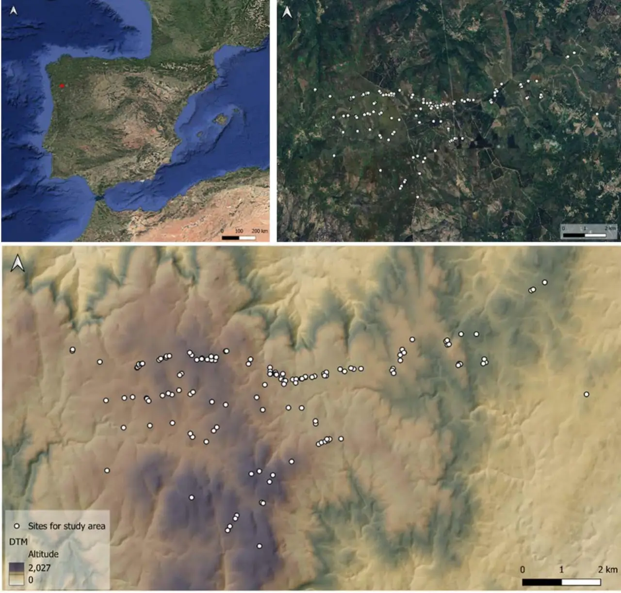
The study area, known as Serra do Laboreiro, sits across the modern border between northern Portugal's Alto Minho region and Galicia in northwest Spain. It belongs to one of the highest concentrations of megalithic sites anywhere in Europe, with over 10,000 recorded tumuli and dolmens scattered across the wider northwest Iberian Peninsula, some dating back to the 5th millennium BC.
Field surveys over the past four decades have steadily expanded the count in this area alone, from 64 known monuments in the early 1980s to roughly 200 by 2012, and approaching 1,000 across the broader region of northern Portugal today. That last figure comes with caveats: Portugal's national archaeological database likely contains duplicate entries from decades of inconsistent recording practices, and the team cautions that systematic field verification is still essential.
For this study, the researchers started with a database of 269 monuments identified through previous fieldwork. They then cross-referenced each site against high-resolution LiDAR terrain models, a process called "ground truthing" that strips away vegetation and modern structures to reveal the bare topography beneath. This step winnowed the dataset to 178 confirmed sites, after removing 46 duplicates and 45 whose identification as burial mounds could not be verified remotely.
Reading the Terrain Like a Prehistoric Builder
The team tested eight landscape variables against the monument locations, using 999 Monte Carlo simulations (a statistical method that generates random point distributions to check whether real patterns differ from chance) to determine which features of the terrain actually influenced where people chose to build.
Seven of the eight variables proved statistically significant. Altitude stood out as the dominant factor: the monuments concentrate between 800 and 1,200 metres above sea level, with a secondary cluster at 400 to 600 metres. Slope, the shape of the horizon, proximity to ridgelines, distance to rocky outcrops, distance to watershed edges, and topographic prominence all played measurable roles. The only variable that showed no significant relationship was cumulative viewshed, the total visible area from each point. According to Miguel Carrero-Pazos of the University of Santiago de Compostela, the corresponding author on the study, this does not necessarily mean visibility was unimportant; rather, the structural variety of the monuments (built across thousands of years by different communities with different priorities) may have blurred any single visual pattern in the data.
What the team found instead is that the monuments tend to sit at the places where the landscape's own structure is most pronounced: along ridgelines that define the horizon, near outcrops of exposed rock, and at the boundaries between drainage basins. These are the features that would have been most immediately recognisable to anyone travelling through the territory on foot.
Marking What Already Mattered
The researchers propose that the burial mounds were materialising a spatial network that already existed in the landscape's own structure. The ridgelines, skyline features, and natural pathways were already significant before anyone raised a single stone. The monuments made those relationships permanent, visible, and social.
This idea gains support from an intervisibility analysis the team ran across all 178 sites. When they mapped which mounds could be seen from which, distinct clusters emerged, groups of monuments with strong visual connections to one another and weaker links to more distant groups. A refined sample of 138 monuments appeared to define the primary territorial layout, suggesting that certain structures (perhaps the oldest ones) had acted as anchoring points around which later building activity organised itself. The study's authors describe this as a kind of "satellitisation," where newer monuments were built in the vicinity of older ones, either reinforcing established spatial patterns or deliberately diverging from them.
This long-term layering of construction is well-documented elsewhere. At Outeiro de Gregos in Serra da Aboboreira (Porto, Portugal), five monuments span from the early 4th millennium BC to the Final Bronze Age, each representing a different architectural style and chronological phase. Micromorphological analysis of other Portuguese sites, such as Anta 1 do Vale da Laje in Tomar, has revealed sequences of activity that include the deliberate clearing of vegetation by fire, construction, abandonment, forest regrowth, and later reuse, sometimes centuries apart.
The Limits of the Digital Map
The team is candid about the limitations of applying statistical tools to a landscape that was built, modified, and reinterpreted over millennia. Treating thousands of years of activity as a single static snapshot inevitably smooths out the very dynamism the researchers want to understand. Most of the monuments in Serra do Laboreiro remain unexcavated, meaning their internal architecture (open dolmens, closed dolmens, passage graves, cists) and their dating remain largely unknown.
Yet the spatial approach offers something that excavation alone cannot: a view of the whole system at once. By analysing the relationship between all the monuments and the terrain they occupy, the study reveals patterns that would be invisible at the scale of a single site.
From the Ground to the Collection
The megalithic traditions of the Iberian Peninsula produced a material culture that extended well beyond the monuments themselves. The communities that raised these mounds were engaged in early forms of farming combined with pastoralism, hunting, and gathering, and their stone tools, pottery, and personal ornaments circulated across the same mountain landscapes their monuments defined. We regularly handle Neolithic and Bronze Age stone tools and related small finds from this broader region and period. Browse our current catalogue for prehistoric European artefacts from comparable traditions.
TimeLine Auctions, 14th May 2026
